.
.
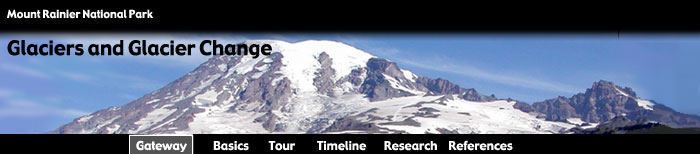
Gateway to the Glaciers of Mount Rainier
Welcome! This site is a place to explore the glaciers covering Mount Rainier, the tallest peak in the Pacific Northwest. It is also a site to find out about glacier change and glacier research on the mountain. Though the site is designed for the general public, it does contain links to technical information useful to those with more professional interests.
Mount Rainier has the largest collection of glaciers on any single peak anywhere in the contiguous United States. This site is dedicated to fostering the enjoyment and understanding of this magnificent resource. In addition to their scenic value, the glaciers of Mount Rainier are important indicators of climate change, and a source of water for hydroelectric power and recreation. Furthermore, the glaciers are important for understanding and predicting the damaging debris flows that are common to the mountain.
This site has five modules that are listed in the title banner at the top of each page. To access a module, click on its name in this list.
The list of modules includes...
- Gateway - This page.
- Basics - Provides basic background information on glaciers and glacier change.
- Tour - An interactive tour of the glaciers of Mount Rainier. Provides information about the geography, glaciers, and climate in the National Park.
- Timeline - An interactive atlas / timeline showing changes in the glaciers of Mount Rainier from 20,000 years ago to 1994.
- Research - Provides information on research techniques, as well as past and current glacier research activities on Mount Rainier.
This site was created for Mt. Rainier National Park by Frank D. Granshaw (Geology Department at Portland State University) and Dr. Andrew G. Fountain (PSU Departments of Geology and Geography). Assistance was provided by Thomas Nylen (PSU Department of Geology), Barbara Samora and Darin Swinney (Mt. Rainier National Park), and Carolyn Driedger (Cascade Volcanic Observatory).
|