| . |
.
Glaciers, Some Basic Ideas
What is a glacier?
A glacier is a perennial mass of ice that is large enough and heavy enough to flow, like a very thick fluid. Glaciers form wherever more snow accumulates than is lost each year. As new snow accumulates, it buries and compresses the old snow. Under the weight of the overlying snow, the old snow is transformed from a fluffy mass of ice crystals into dense, hard ice. This process occurs on the upper part of a glacier, at higher altitudes, where more snow accumulates than is lost each year. This is called the “accumulation zone”, and is typically covered with snow year-round. The glacier is in constant motion, and the ice in the accumulation zone flows down to lower altitudes, which is called the “ablation zone”. The ablation zone is located in the lower part of the the glacier where more snow is lost than accumulates. In late summer, when the seasonal snow has melted away from the surrounding valley walls, bare ice of the ablation zone is exposed.
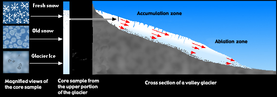
Figure 1 - Cross section of an alpine glacier showing snow being converted into glacier ice (the left side of the figure) and the two major zones of a glacier’s surface. The red arrows show the direction and relative speed of different parts of the glacier. The longer the arrow, the faster ice is moving.
The Anatomy of a glacier
All glaciers have accumulation and ablation zones. The boundary between these two zones, the equilibrium line, is the transition where accumulation equals ablation.
The accumulation zone has three major layers. The top layer is snow that thickens further up glacier. The next layer is the “firn”, or a transitional form between the snow and solid ice below. The bottom layer is ice. During the winter, the ice of the ablation zone is covered with snow, which entirely melts away in summer.
Rock debris covers the ablation zone of some glaciers on Mount Rainier The rocks fall from the valley walls directly onto the glacier and then are carried down valley by the glacier. Eventually the rock is deposited at the end or along the sides of the glacier. Where the rock piles up at the end of the glacier, a ridge forms, which is called a moraine . If the ridge forms on the side of a glacier it’s called a lateral moraine; if it forms at the end of the glacier it’s a terminal moraine. The occurrence of moraines are important because they are used to determine the size of glaciers during earlier, colder times. Old lateral and terminal moraines are very common at Mount Rainier.
Meltwater streams flow from the down valley end (terminus) of all the glaciers on Mount Rainier. The streams originate as meltwater and rain on the glacier surface. The water makes its way into the interior of the glacier through crevasses that are commonly found on the ice surface (c) . Occasionally, surface water drops into “moulins” or circular shafts that descend vertically from the surface into the glacier. Once in the body of the ice water flows in naturally formed cracks or tunnels. Eventually, the water reaches the bottom of the glacier where it flows between the rock and the ice. The water may flow within saturated sediments that are sandwiched between the ice and rock, or in small cavities formed on the downslope side of bumps in the bedrock. The water eventually ends up in tunnels which appear as streams at the end of the glacier. Under certain circumstances, the stream exit can expand into a large ice cave. The most famous of these caves on Mount Rainier, those in Paradise Glacier, disappeared in the 1970's as the glacier retreated. Ice caves are dangerous, however, because they occur where the ice is thin and subject to collapse.
The streams then travel across rock strewn fields, which are stream-modified glacial deposits called outwash plains. Finally, the streams cascade over cliffs into the heavily forested valleys. In some cases these streams flow out of ice caves at the bottom of the glaciers. In nearly all cases, streams flowing from glacier termini are clouded with fine sediment giving the streams a milky appearance. This sediment (glacial flour) is created by the glacier grinding its rocky bed. This happens when rocks carried by the glacier, imbedded in the ice at the glacier bottom, scrape along the bottom and act like sandpaper to grind down other rocks.
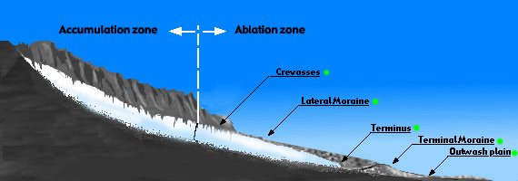
Figure 2 - A cross section of an alpine glacier. Click on a green dot next to a feature name to view a photograph of that feature.
Types of glaciers
Most of the glaciers on Mount Rainier are known as valley glaciers. These are glaciers are confined to a valley (usually a former stream valley). Three good examples of this type of glacier are Nisqually, Carbon, and Emmons glaciers. The smallest glaciers on Mount Rainier are cirque glaciers. These are small glaciers that occupy a bowl-shaped basin at the head of a mountain valley. Cirque glaciers are usually the remnants of much larger valley glaciers. An example of this type of glacier is Inter Glacier.
Another type of glacier, called a continental glacier, is a large ice sheet that covers thousands of square kilometers. Although there are no continental glaciers in the Mount Rainier area today, 15,000 years ago much of the Puget Sound west of Mount Rainier was covered with a continental glacier over 1000 m (3300 ft) deep. At least one of the current glaciers on Mount Rainier may been a tributary of this ice sheet.
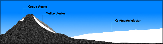
Figure 3 - A cross section of a mountain and its surroundings showing the three major types of glaciers.
Glaciers as Sculptors
Glaciers have shaped Mount Rainier. First, they have been constantly eroding it, reducing its height by an estimated 300 meters (1000 feet) over a period of 6000 years (c) . Glacier erosion has carved cirques and deep U-shaped valleys in the flanks of the mountain. Glaciers erode in two ways. First, they pluck rocks from the base under the glacier by either freezing on to them or by breaking them off subglacial ledges. The plucked rocks are dragged by the moving ice over the rock remaining in place. The rock studded ice acts like sandpaper to grind bedrock. Aside from grinding the volcano down, the glacier also piles rock into moraines, as explained earlier. One of the best places to see well developed terminal and lateral moraines is at the lower end of Emmons Glacier in White River Canyon. A good place to see the after effects of plucking and abrasion is below Paradise Glacier, where several roche moutannées lie near the edge of a hanging valley.
Another way glaciers have shaped Mount Rainier is by the interaction of ice with volcanic eruptions. Evidence from the margins of cooled lava flows below Paradise Glacier indicate that during major ice ages, erupting lava would flow along the margins of glaciers or in meltwater trenches on the glacier. In some instances lava flows would be temporarily dammed by glaciers until they were able to melt through them (c). One result of this interaction is the high ridges of resistant rock that separate deep valleys. One such ridge, Mazama Ridge, formed along the margin of the ancestral Paradise Glacier.
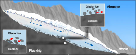
Figure 4 - A cross section of a glacier showing plucking and abrasion.
Glaciers and the Ecosystem
Glaciers are important regulators of water flow. In dry hot summers glaciers generate lots of meltwater, and during cool wet summers they melt much less (c). Consequently, glacier-fed streams have a relatively small annual variation in streamflow compared to streams from ice-free valleys. This is a particularly important in the Pacific Nortwest where dry summers typify our climate. The ecosystems that develop along the glacier-fed streams are dependent on this steady source of cool stream water, and its habitat is different from that surrounding an ephermeral stream. Glacially fed streams provide important habitat for many native species of fish and amphibians such as Bull Trout, Coastal Cutthroat Trout, and Cascades and Tailed Frogs that are listed as Species of Concern under State and Federal programs. The glacier flour obscuring the clarity of the glacial streams provides lots of nutrients for the aquatic microbial life. However, the flour also reduces the penetration of sunlight in the water which adversely affects some aquatic plant and animal species. Glacier recession, which has been on going since the early 1900’s, is opening new habitat (c). Plant and animal colonization of these new areas can be often observed.
-
Glaciers and Geologic Hazards
One of the significant hazards associated with Mount Rainier are torrential floods of water, rock, and other debris that begin when water periodically bursts out from glacier valleys. Because the mountainsides are made up of highly fractured rock and accumulated rock debris, glacier floods can mix with the rock debris to produce a thick rocky slurry, called a debris flow. These debris flows travel a short distance beyond the base of the volcano carving deep canyons, uprooting trees, and destroying roads, bridges, and trails within the national park. One of the most recent of these debris flows took place on August 15, 2001 when water from the side of Kautz Glacier flowed over a ridge and into Van Trump Creek Canyon, where it converted a clear running stream into a turbulent flow of mud and rocks.
Climate determines how much snow a glacier receives and how fast it melts. The part of the year when glaciers gain more ice than they lose is called the accumulation season. In the Pacific Northwest, the accumulation season is usually from October to May (c). The part of the year when glaciers lose more ice than they gain is the ablation season, generally from June through September. During a cool, wet year, glaciers gain more snow than they lose, causing the glacier to advance. During warm, dry years, they melt more snow and ice than they receive, causing them to retreat.
Although glaciers always flow downhill, the idea of glacier “retreat” may give the impression that a glacier can move uphill. In fact, a glacier is in retreat when the rate of movement downhill cannot keep up with the rate of melting. The glacier is melting back faster than it is moving downhill, so it is said to “retreat”. By contrast, when a glacier advances, its downhill flow is greater than the melt at the terminus. Changes in glacier size (advance and retreat) depend on the climate including air temperature and snowfall.
The position, orientation, or elevation of a glacier affects the magnitude of glacier change in response to climate. For instance, south facing glaciers on Mount Rainier have retreated faster than north facing glaciers over the past 80 years. The glaciers on the south side are generally smaller and lower in elevation (on average) than the north side glaciers, making them more susceptible to changes in the freezing level (c).
Another locally determined characteristic is rock cover. The Emmons Glacier experienced a rock avalanche in 1963, which covered part of the glacier with a layer of rock debris. This debris now insulates the ablation zone of the glacier from sunlight and warm air temperatures and the melting of the glacier is smaller than from an otherwise clean glacier. Because melting is reduced, but the ice flow is the same, the glacier is advancing. This response has nothing to do with climate change.
Over the last century the glaciers of Mount Rainier have retreated significantly (c). While the response of each glacier depends on its local conditions, glacier loss seems to be largely the result of a regional tendency toward warmer weather, resulting in less snowfall and high rates of ablation (the loss of snow and ice by melting). The recent retreat of the Mount Rainier glaciers during the late 80's and 90s is primarily caused by warmer than average summer temperatures and drier winters. Prior to the late 80s the glaciers were advancing because of wetter winters and cooler summers. These two factors are the primary driving force behind glacier changes. Summer temperatures control the amount of mass (ice) lost and winter precipitation adds mass (snow) to the upper part of glaciers (c).
For more information on glacier and climate change on Mt. Rainier go to the "Timeline of Glacier Change"
-
|
|
, |
|