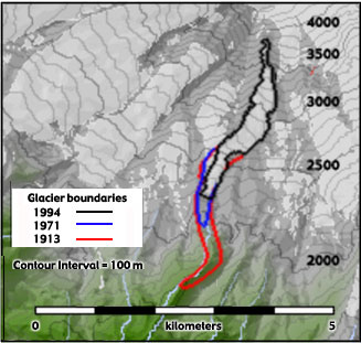
 Figure 1 - Contour / Relief Map of Kautz Glacier Figure 2: Scenes from the August 15, 2001 Kautz - Van Trump debris flow. Video footage recorded by Carolyn Driedger (Cascade Volcanic Observatory - U.S. Geological Survey).
|
|
General Information: Kautz Glacier is located immediately west of Nisqually Glacier on the mountain's southeastern flank. Beginning at nearly 4000 meters (13,100 feet), the glacier extends less than 4 kilometers (2.5 miles). Although Kautz glacier is one of the smallest on the mountain, it is a significant player in the recent geologic history of the park. Twice during the last century, the Kautz was the site of major mudflows. In October 1947, water abruptly drained from underneath the glacier, ripping away a section of glacier over 1.2 kilometers (1 mile) in length and gouging a 100 meter (320 foot) deep canyon once occupied by the ice. Downstream, the water mixed with rock, trees, and other debris to form a fast moving slurry that flowed across the park highway almost 10 kilometers (6.2) miles away. Another catastrophic flood occurred in August 2001 when water bursting from Kautz glacier produced a lahar that flowed over a ridge and into Van Trump Creek (see Figure 2). Text adapted from A Visitor's Guide to Mt. Rainier Glaciers by Carolyn Driedger. Viewing Kautz Glacier: Your best view of Kautz glacier is from Mildred Point. To reach the point, start at the trailhead at the small parking lot just west of Christine Falls (about 10 miles east of Nisqually Entrance). The glacier is also visible from the Kautz Creek Parking Lot on the Nisqually Entrance Road. |