Viewing Cowlitz and Ingraham Glaciers: You can see the confluence of Cowlitz and Ingraham Glaciers by hiking the trail from Paradise Lodge to the ridge east of Paradise-Stevens Glacier. It is an 11 kilometer (7 mile) journey round trip. |
General Information:
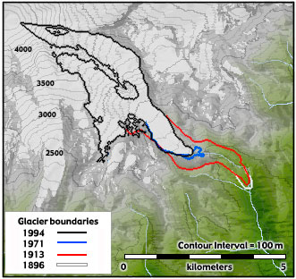
Cowlitz and Ingraham are two glaciers that share a common terminus. Separated by a rocky ridge named Cathedral rock, the two glacers merge at the 2022 meter (6700 foot) level, to create a single stream of ice that flows down into the Middle Fork Cowlitz River Valley. Below the ridge, a ribbon of rocky debris called a medial moraine produces a dark streak in the middle of the glacier. Further down the glacier are a series of concentric debris covered ridges called Ogives. Orgives are bands of dirty ice formed by the annual dusting of open crevasse walls where ice pours over a rock ledge. Below the ridge, ice carries a trail of rock debris that was scraped from the rock bluff above. More than 35,000 years ago, the ancestral Cowlitz Glacier, merged with several other glaciers to become a single stream of ice that flowed nearly 100 kilomters (62 miles) from the mountain's summit. By the end of the Little Ice Age, a little over 100 years ago, the glacier had retreated to within 9.5 kilometers (5.9 miles) of the summit. By 1994 the longest segment of the glacier was less than 7.0 kilometers (4.4 miles) long. Text adapted from A Visitor's Guide to Mt. Rainier Glaciers by Carolyn Driedger. |