
|
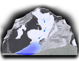
Questions about Glaciers, Climate and Streamflow What is a glacier? A glacier is a mass of ice that is thick enough to flow downhill. Its flow is like a thick fluid that requires a threshold of weight before it begins to move. Glaciers form wherever yearly snowfall exceeds the loss of snow. For glaciers in relatively warm climates like Washington State or British Columbia, abundant winter snow (mass gain) exceeds the loss of snow due to summer melt (mass loss). A glacier can be divided into two regions. At the high end of the glacier, more snow (mass) accumulates than is lost every year. This region is called the accumulation zone. As new snow falls, it buries snow remaining from prior years. When this happens, the old snow is compressed by the weight of the overlying layers and helps to convert snow from a light, air-filled mass of ice crystals into dense, solid ice.
The ice flows downhill into the lower region where more snow (mass) is annually lost than is gained through snowfall. The lower region is called the ablation zone, and by late summer its surface is free from snow exposing the bare ice below. Ablation is a term that means mass loss in all its forms, and it includes melting, sublimation, and calving of ice. The transition between the two zones, where annual accumulation equals ablation is called the equilibrium line. This line is visible at the end of summer as the transition between the snow-covered portion of the glacier and the lower ice-exposed section. The equilibrium line is an important concept, because its location shows what fraction of the glacier is gaining or losing mass, and because the location of the line is controlled entirely by climate and not by glacier flow. Observed changes in the position of the line on a glacier indicate whether the past year has been a good or bad one for glacier growth. If you dug down into the accumulation zone of a glacier, you would find three main layers. The top layer is snow that thickens further up the glacier. Below this layer is firn, a transitional layer between snow and ice, which is as hard as ice but not as dense. The deepest layer is ice. The snow and firn are thickest at the top of the glacier and thin down-glacier to zero at the equilbrium line. The firn and surface ice are rigid, so when the tension due to its flow becomes too great the ice cracks forming crevasses. Deep in the glacier, where the ice experiences the weight of all the snow, firn, and ice above, the ice is softer and deforms much like "silly putty" such that the stiff surface layers ride on the deforming softer layers deeper in the ice.
A few of the glaciers in the Upper Skagit River Basin have a layer of rocky debris (rock, sand, and silt) covering the ablation zone. This debris either fell from valley walls or was ripped from the bed of glacier and then was carried downslope by the glacier. (Note: the accumulation zone is never covered with debris because it quickly gets buried in snow). Eventually, this debris is deposited at the end of the glacier or along its sides forming a ridge called a moraine. When the ridge forms on the side of a glacier, it is called a lateral moraine. When it forms at the lower end of the glacier, the terminus, it is called a terminal moraine. Moraines are important features because they are used to determine the size of glaciers during earlier and colder climates. At the terminus of the glaciers meltwater streams leave the ice and flow across rock covered landscape (outwash plains) before entering heavily forested valleys. When hiking in the forest you can tell which streams are from glaciers since they have a milky appearance. This appearance is produced by fine sediment (glacial flour) that is suspended in the water and created by glacier grinding. A glacier is sort of like sandpaper, except the rocks are carried in the ice. As a glacier moves down hill, it plucks rocks from the bedrock and carries them along the base grinding them back into the bedrock.
What types of glaciers are in the Upper Skagit River Basin Glaciers can be classified according to a number of different schemes. In one scheme they are divided into groups based on their temperature. In another, they are grouped according to their topography (shape and orientation). All the glaciers in the Upper Skagit Basin are temperate (warm) alpine glaciers. A temperate glacier is one where most of its ice is close to the melting point for the entire year. This constrasts with polar or "cold" glaciers that are well below the melting point all year. An alpine glacier is one whose shape is controlled by the topography of mountainous areas. Within the alpine classification, most of these glaciers fall into one of two types.
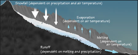
What's the connection between glaciers, climate, and streamflow? The balance between accumulation and ablation is called mass balance, and depends largely on climate. For instance, during a warmer year more winter precipitation will fall as rain instead of snow and in the summer melting increases. During a drier year, winter snow fall will also decrease. In both cases, more ice (mass) is lost than is gained, meaning that the glacier has a negative mass balance. This results in the glacier shrinking (retreating). In contrast, during colder and/or wetter years, a glacier has a positive mass balance, caused by increased snowfall and decreased melting, and so the glacier grows (advances).
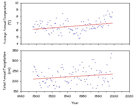
Ironically, most glaciers in the Upper Skagit River Basin shrank during the twentieth century despite increased precipitation. This is due to changes in winter temperature. (c) During the last century, average annual temperature for the North Cascades increased by 0.9°C. (c) This meant that despite increased precipitation, snowfall decreased while melting increased.
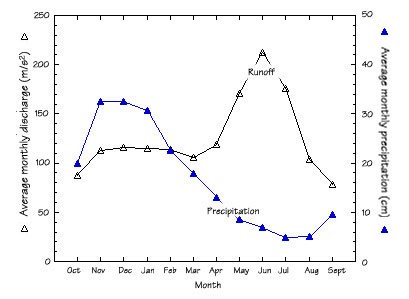
So what is the connection between glaciers and streamflow? Beginning in spring the accumulated snow melts, feeding alpine streams. By late summer, much of the seasonal snow cover has disappeared from the landscape. The glaciers remain, however, and the melt from their vast reservoir of ice supply water during the driest part of the northwest summer. This is particularly important for summer during drought years. Figure 8 shows precipitation peaking in November and December, and streamflow peaking in June just as precipitation is at its lowest for the year. The peak in streamflow is caused by snow melt, and the beginnings of glacier melt. Note that the August streamflow is as high as winter streamflow, but during a period of much less precipitation. The source of August stream flow is the melting of the last of the patches of snow cover and of the glaciers.
|
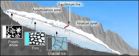
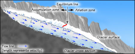
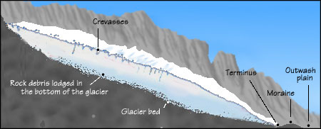
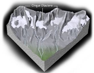 Figure 4 - Unnamed cirque glaciers in Redoubt Creek Watershed