Introduction
|
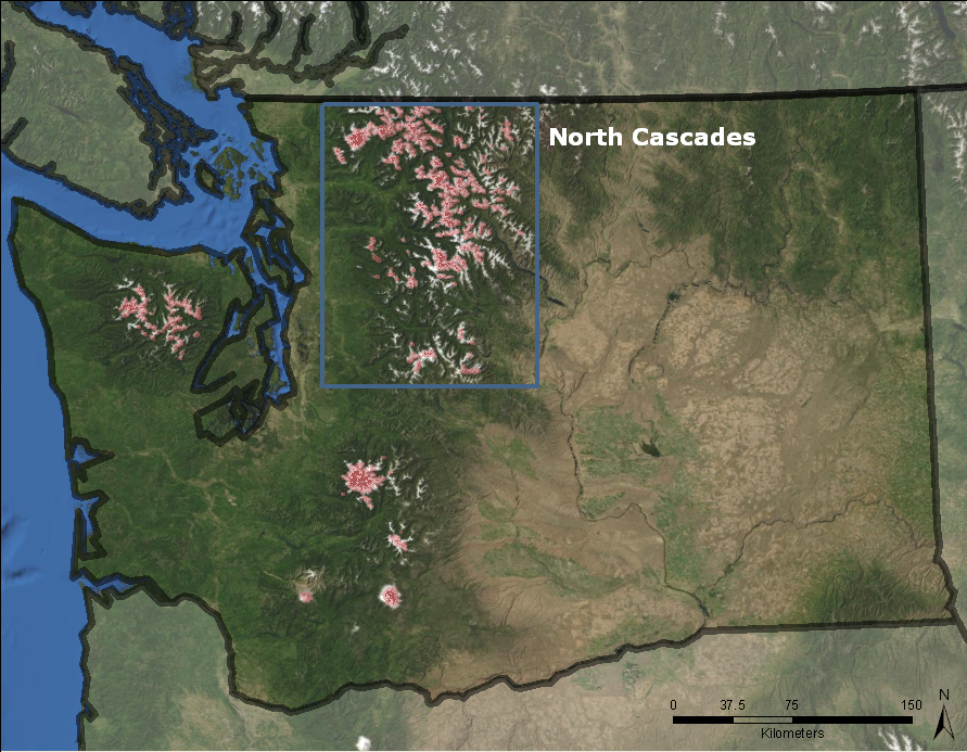
The North Cascades is the most glaciated region in the lower-48 states with a total glaciated area of about 118 km2. Yet, little research has examined the trend of change for the region. The total glacier area shrunk by approximately 7% between 1958 and 1998. Some individual glaciers have continued to shrink during the early 2000s (~10%). The purpose of this research is to quantify the magnitude and rate of regional glacier area in response to climate variations and to define contributions to streamflow. |
 |
Background
Glaciers respond to local climate changes making them important indicators of climate change. Mountain glaciers respond to changing climate conditions on a roughly decadal time scale (Johnneson et al. 1989), whereas smaller glaciers respond more quickly (Hoffman et al.,2007). The Intergovernmental Panel on Climate Change has used glaciers as an indicator of climate change since 1990 (Houghton et al. 2001). Between 1961 and 1998 alpine glaciers and ice caps have contributed about 13mm to global sea-level rise, about 20% of the total observed sea-level rise (Dyurgerov and Meier 2000; Dyurgerov 2002). The effects of mountain glacier change can also be seen at the regional and local levels. As mountain glaciers recede, alpine ecosystems are affected by shifts in runoff timing (Hall and Fagre 2003). Further downstream, regions rely on glacier runoff for agriculture, hydropower and consumption (Fountain and Tangborn 1985). |
North Cascades
The North Cascades region stretches from latitude 48oN to the Canadian Border (49oN) and between 122o 30' and 121o 30' W in Washington State spanning about 20,000 km2. The elevation ranges from less than 1,000m to 3,285m at the peak of Mount Baker. The North Cascades region has approximately 1,638 perennial snow/ice features with an area of 118 km2 (Fountain et al. 2007a). Topography and semi-permanent high/low pressure systems over the Pacific Ocean control the weather patterns in the North Cascades. The western half has mild, wet winters with cool, dry summers and the eastern half has cold winters and hot summers (Climate of Washington 1985). Average precipitation ranges from 120-325 cm (Post et al. 1971). | 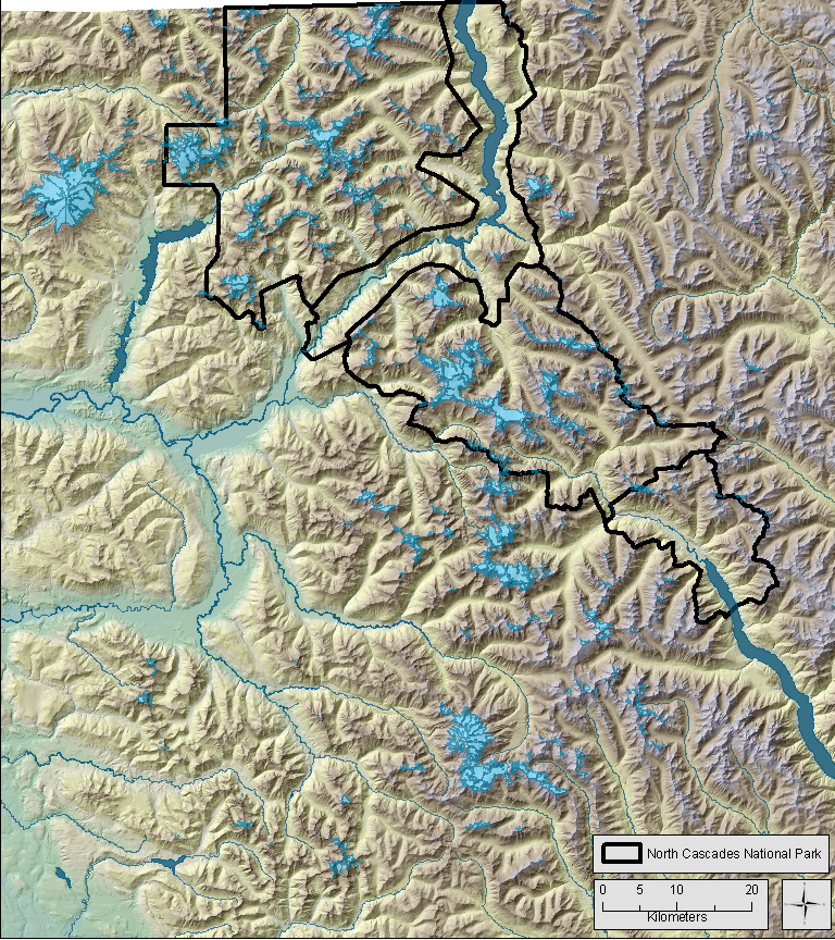 |
Previous Work
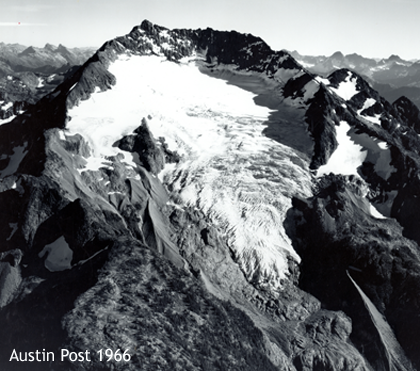
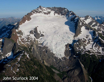
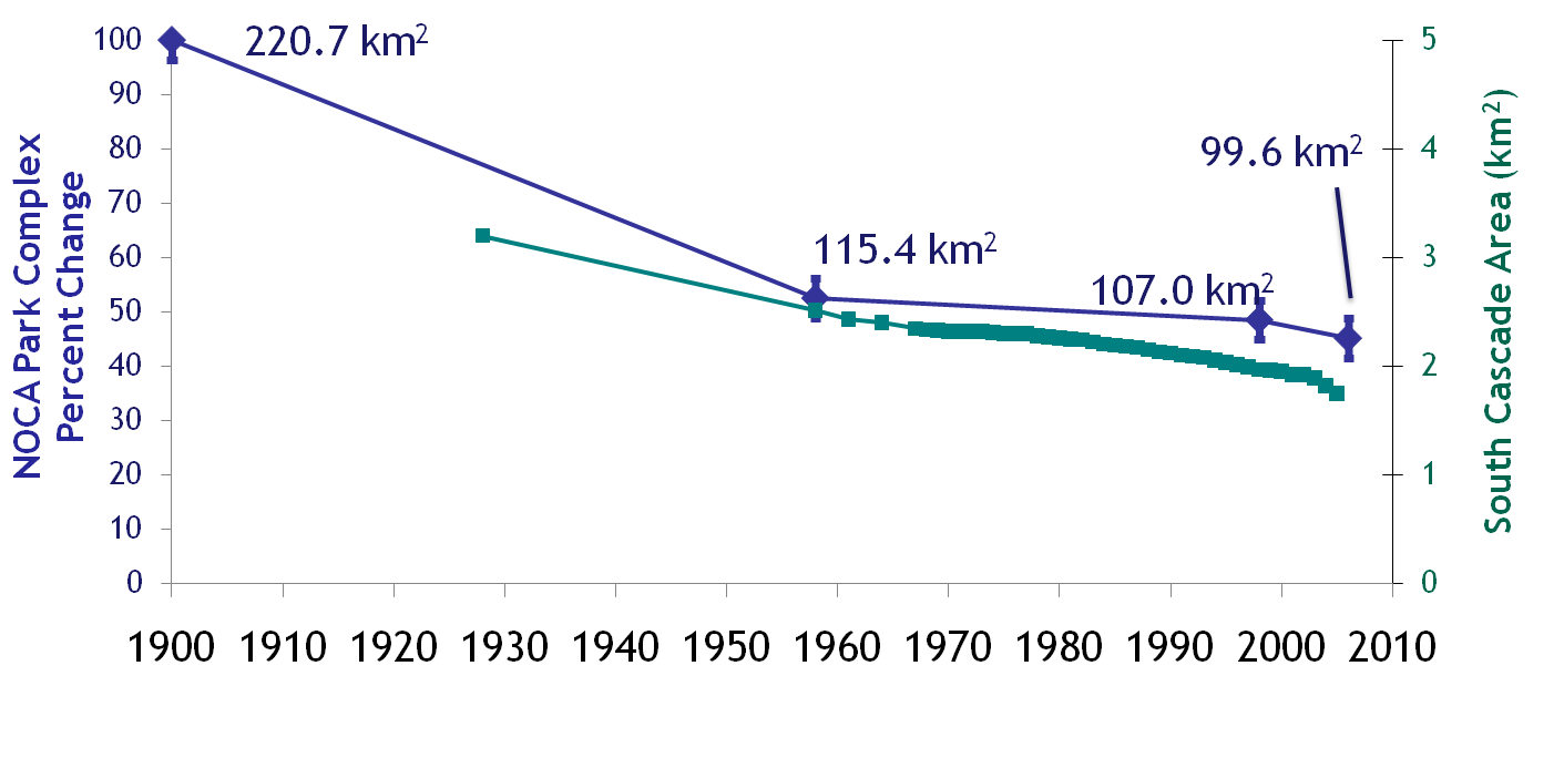
The first published account of glaciers in the North Cascades was by I.C Russell in 1897 when he recognized glaciers in the mountains of the North Cascades (Russell 1897). The first comprehensive survey of glaciers in the North Cascades identified 756 glaciers > 0.1 km2 (Post et al.1971). A comparison of glacier change focused on the North Cascades National Park Complex found 316 glaciers (109.1 +/- 1.1 km2) in 1998 (Granshaw and Fountain, 2006) compared with 321 glaciers (117 +/- 1 km2) in 1958 (Post et al. 1971). The glaciers had decreased by ~ 7% with small glaciers losing relatively more area than larger glaciers. Between 1958 and 2003, the South Cascade Glacier has retreated about 0.6 km from its 1958 terminus position and the average net balance was -0.55 m water equiliviant (Bidlake et al. 2007). The NPS monitored glaciers experienced a short period of stability in the late 1990s, and since then the trend has been negative (Riedel 2008). The NCGCP monitored glaciers has shown an overall cumulative negative mass balance trend since 1984 (Pelto 2008). |
Methods
I am going to update the previous glacier inventories for the entire North Cascades. The Post et al. (1971) inventory covers the entire North Cascades range from Snoqualmie Pass to the Canadian border. The Granshaw and Fountain (2006) inventory based on USGS 1:24000 topographic maps updated the Post et al. (1971) inventory within the North Cascades National Park Complex based on available imagery. The 2006 and 2009 glacier outlines will be digitized using a GIS based on the imagery from the National Agricultural Imagery Program (NAIP). The 2006/2009 glacier outlines will update the entire North Cascades region. Black and white aerial photography taken at various dates throughout the region will be used to add an additional timestep to the glacier inventory. This data covers the entire North Cascades region. Additional data provided by the North Cascades National Park include Little Ice Age (LIA) extents (Jon Riedel, personal communication). This data will provide the ~1900 glacier extents. This dataset covers the North Cascades National Park complex. |
I will examine trends in runoff to determine any effect caused by shrinking glaciers. Fountain and Tangborn (1985) identified 33 glaciated and non-glaciated basins within the North Cascades with suitable runoff measurement stations. These basins will be used to identify runoff trends. The monthly streamflow data will be downloaded from the USGS. The location of the USGS stream gages will be used to derive drainage basins in ArcGIS. To isolate the effects of glacier changes from direct effects of climate, PRISM temperature and precipitation will be used. To account for precipitation trends in the runoff, zonal statistics will be calculated from the total precipitation amounts over the entire drainage basin. I will also subtract them from the volume runoff. The removal of precipitation from streamflow should indicate glacier runoff trends over time. |
Preliminary Results
Within the North Cascades National Park complex, there has been continuing decrease in overall glacier covered area between 1998 and 2006. |
References
Bidlake, W.R., E.G. Josberger and M.E. Savoca 2007. Water, Ice, and Meteorological Measurements at South Cascade Glacier, Washington, Balance Years 2004 and 2005. U.S. Geological Survey. Cooper, R.N., J.T. Houghton, J.J. McCarthy and B. Metz 2002. Review of Climate Change 2001: The Scientific Basis. Foreign Affairs, 81(1): 208-208. Dale, R.F. 1966. U.S. Weather Bureau Climatography of the United States. No. 60-4: Climate of California. Washington, U. S. Government Printing Office, 37. Dyurgerov, M., M. Meier, R.L. Armstrong, B.I.o.A. University of Colorado and R. Alpine 2002. Glacier mass balance and regime : data of measurements and analysis. Boulder, Colo., Institute of Arctic and Alpine Research, University of Colorado. Dyurgerov, M.B. and M.F. Meier 2000. Twentieth Century Climate Change: Evidence from Small Glaciers. Proceedings of the National Academy of Sciences of the United States of America, 97(4): 1406-1411. Fountain, A.G., S. Geological, G. Portland State University. Dept. of and G. Portland State University. Dept. of 2007. Digital outlines and topography of the glaciers of the American West. Reston, Va., U.S. Geological Survey. Fountain, A.G. and W.V. Tangborn 1985. The Effect Of Glaciers On Streamflow Variations. Water Resources Research, 21(4): 579-586. Granshaw, F.D. and A.G. Fountain 2006. Glacier change (1958-1998) in the North Cascades National Park Complex, Washington, USA. Journal of Glaciology, 52(177): 251-256. Hall, M.H.P. and D.B. Fagre 2003. Modeled Climate-Induced Glacier Change in Glacier National Park, 1850-2100. Bioscience, 53(2): 131-140. Hoffman, M.J., A.G. Fountain, and J.M. Achuff. 2007. Twentieth-century variations in area of cirque glaciers and glacierets, Rocky Mountain National Park, Rocky Mountains Colorado, USA. Annals of Glaciology 46: 349-354. Johanneson, T., C. Raymond, and E.D. Waddington. 1989. Time-scale adjustment of glaciers to changes in mass balance. Journal of Glaciology 34: 355-369. Pelto, M.S. 2008. Glacier annual balance measurement, forecasting and climate correlations, North Cascades, Washington 1984-2006. Cryosphere, 2(1): 13-21. Riedel J.L. 2008. Glacier Monitoring Program: Long Term Trends. http://www.nps.gov/noca/naturescience/glacial-mass-balance7.htm (last accessed 09 November 2009). Russell, I.C. 1897. Glaciers of North America. Boston, Ginn and Company. |
Links
Glaciers of the American West
|
Created on September 22, 2010
Questions? Comments? Contact kthorney (at) pdx.edu