Justin
Ohlschlager
Masters Candidate
jgo2@pdx.edu
Department of Geology
Portland State University
P.O. Box 751
Portland, OR 97215
Justin
Ohlschlager
Masters Candidate
jgo2@pdx.edu
Department of Geology
Portland State University
P.O. Box 751
Portland, OR 97215
The Changing Surface Area and Volume of the Glaciers on the Three Sister Volcanoes, Oregon
Introduction
Since the maximum of the Little Ice Age, approximately 150
years ago, the glaciers in the Pacific Northwest have been losing both
volume and surface area (McDonald, 1995, Jackson and Fountain, 2007,
Marcott et al., 2009, Sitts et al., 2010). Anticipated warming air
temperatures (IPCC, 2007) suggest that this loss will continue. Shrinking glaciers have serious ramifications
for debris flow hazards and diminished local water
resources. Increasing frequency of debris flows will occur due to
glacier retreat and no longer buttressing the glacially-carved valley
walls on the volcanoes of the Northwest (O’Connor et al., 2001). Glaciers are major contributes to local alpine
runoff in the late-summer months, when the need for water is the
greatest during those drier months (Fountain et al., 1998). While the shrinkage of glaciers removes ice
from long-term storage and exports it as runoff, supporting
drought-affected stream flow, smaller glaciers have reduced capacity to
export the water volume needed to maintain the flows at historic levels.
An assessment of changes in glacier area has not been completed for the Three Sisters Volcanoes, located in Central Oregon (Fig. 1). The most studied glacier in the region, Collier, was the subject of a study investigating the changes in mass from 1910-1994 (McDonald, 1995). This study is now 17 years old and it looked at only the Collier Glacier. A total inventory of both the ice area and thickness was completed in 1986, using ground-penetrating radar and surface area-volume estimates (Driedger et al., 1986).
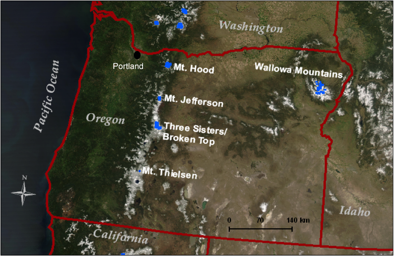
Figure 1. Map showing the location of the Three Sisters Volcanoes in the Cascades of Central Oregon (NASA MODIS image, 4.26.2004).
My thesis will estimate the area change of glaciers (Fig. 2) on the Three Sisters based on photographs (ground-based and aerial) and maps. The earliest photographs date to about 1910 and the most recent were acquired in 2010. I will also estimate volume change using oblique hand-held photographs. New advances in digital photogrammetry allow rendering objects in three-dimensions from cameras held at arbitrary angles (EOS, 2004). This offers the tantalizing possibility to derive quantitative surface topography from historic oblique photographs. Often, historic hand-held photos are the only record of past glacial extents.
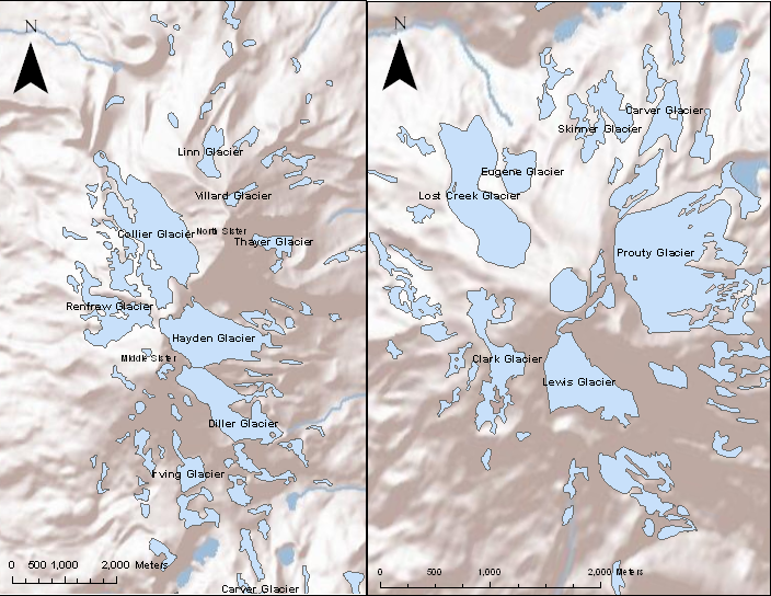
Figure 2. Map showing location and extents of the
glaciers on the Three Sister volcanoes in Central Oregon. Outlines are
from the 1:24,000 USGS topographic maps. The map on the left is North
and Middle Sister and the map on the right
is South Sister.
Methods
Glacial surface areas will be quantified on the Three Sisters
Glaciers using a GIS (Geographic Information Systems) whereby historic
aerial photographs (Fig. 3) will be georectified using the latest,
usable, NAIP orthophotographs (Basagic and Fountain, accepted) and
glacier outlines in the photography and imagery will be digitized.
Glacier perimeters will be inferred from oblique hand-held photography
where necessary to extend or fill gaps in the data record (Sitts et
al., 2010).
To estimate the historic surface topography of the glaciers I use
PhotoModeler, a software program designed to render three dimensions
from a series of overlapping photographs taken from different angles
(EOS, 2004). This software has been used successfully to map the
topography of dome growth at Mount Saint Helens during the 2004-2008
period (Major et al. 2009). From the topographic surfaces
rendered in 1910 and in 2010, the difference in surface elevation will
be calculated and volume loss estimated. For control, I will also
map the topography of local bedrock and differences there will be used
as an estimate of error for the glacial surfaces (Sisson et al., 2011).
Figure 3. Photos of Collier Glacier, situated between
North and Middle Sister, in 1910 (left, photo R. Simms) and 1993
(right, photo Weiprecht (USGS)). Significant loss is seen in surface area between the two photos.
Field Work
To provide the most updated information on area and volume change I will acquire new photographs in maximum snow melt, late August/early September. Photographs taken in 2010, the 100th anniversary of the first photos are taken too early in the summer and seasonal snow obscures part of the landscape. Therefore, I need to reoccupy the same photograph points, but much later in the season when seasonal snow is at a minimum.Impacts
An assessment of volume change is a much more useful metric,
compared to area change, in linking glacier change to climate and to
effect on alpine stream flow. Area changes are noisy indicators
due to the dynamics of glacier response to mass input and area-volume
relations which are not constant over time. Therefore knowledge
of volume changes over the past century will provide a more accurate
assessment of glacier change in response to climate.
Perhaps the greatest impact from the project would be the evaluation of
a new technique to estimate glacier topography. Application of
Photomodeler to glaciers and for assessing glacier change has not been
done previously. If successful, this technique will be a valuable
tool in the analysis of past glacier geometries from photographs from
the past, which would give the ability to better utilize data sets (old
photos) to there fullest potential.
References
Basagic, H.J, and Fountain, A.G., Accepted, Twentieth Century
Glacier Change in the Sierra Nevada, California, Arctic, Antarctica,
and Alpine Research.
Driedger, C.L., and Kennard, P.M., 1986, Glacier Volume Estimation On
Cascade Volcanoes: An Analysis And Comparison With Other Methods,
Annals of Glaciology, v. 8, p. 59-64.
EOS, Systems Inc. 2004, PhotoModeler User Manual.
Fountain, A.G., and Wader, J.S., 1998, Water Flow Through Temperate
Glaciers, Reviews of Geophysics, v. 36, p. 299-328.
Intergovernmental Panel on Climate Change (IPCC), 2007, The AR4
Synthesis Report.
Jackson, K.M., and Fountain A.G., 2007, Spatial and morphological
change on Eliot Glacier, Mount Hood, Oregon, USA. Annals of Glaciology,
v. 46, p. 222-226.
Major, J.J., Dzurisin, D., Schilling, S.P., and Poland, M.P., 2009,
Monitoring lava-dome growth during the 2004-2008 Mount St. Helens,
Washington, eruption using oblique terrestrial photography, Earth and
Planetary Letters, v. 286, p. 243-254.
Marcott, S.A., Fountain, A.G., O’Connor, J.E., Sniffen, P.J., and
Dethier, D.P., 2009, A latest Pleistocene and Holocene glacial history
and paleoclimate reconstruction at Three Sisters and Broken Top
Volcanoes, Oregon, USA, Quaternary Research, v. 71, p. 181-189.
McDonald, G.D., 1995, Changes in mass of Collier Glacier, Oregon [M.S.
thesis]: Oregon State University, 215 p.
O’Connor, J.E., Hardison, J.H.I., and Costa, J.E., 2001, Debris flows
from failures of Neoglacial age moraine dams in the Three Sisters and
Mount Jefferson Wilderness Area, Oregon, U.S. Geological Survey
Professional Paper 1606, 93 p.
Sitts, D.J., Fountain, A.G., and Hoffman, M., 2010, Twentieth Century
Glacier Change on Mount Adams, Washington, USA, Northwest Science, v.
84, p. 378-385.
Sisson, T.W., Robinson, J.E., and Swinney, D.D., 2011,
Whole-edifice ice volume change A.D. 1970 to 2007/2008 at Mount Rainier, Washington,
based on LiDAR surveying, Geology, v. 39, p. 639-642.
Last Updated: July 13, 2011