Results and Analysis
Over three seasons of fieldwork we drilled 51 holes penetrating a total of 3.9 km of ice. About 78% of the holes intercepted an englacial drainage passage. A total of 81 cavities were imaged within the glacier by the submersible camera. In this context, a cavity refers to any void in the ice, including englacial drainage features as well as isolated, non-draining cavities. Almost half of the holes had multiple cavities. Occasionally, while drilling, the water level dropped for a minute or so before returning to the ice surface, suggesting an intersection with an isolated air-filled cavity.
Of the 45 cavities that were measured, 36 (80%) were crack-like features, 2 (4%) were circular in cross-section and the remaining 6 (16%) were of ambiguous geometry. The crack-like features exhibited sub-parallel walls with near vertical dip. They were observed at all depths, from the near surface to 96% of the local glacier depth; the deepest fracture observed was 131 m below the surface. This fracture was also connected to the englacial hydraulic system. Fracture orientation (strike) was generally parallel to strain-related features on the surface of the glacier. A few strikes, particularly those at depth, were 40°-60° to the east from the main orientation. The width of fracture openings varied from 0.3 to 20 cm with a median of 4 cm and did not correlate with fracture depth. Over long distances (~100s m) the hydraulic gradient in the fracture system appears to mirror that of the surface slope of the glacier. Examples of the observed features are shown below.
Mostly what we found
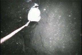
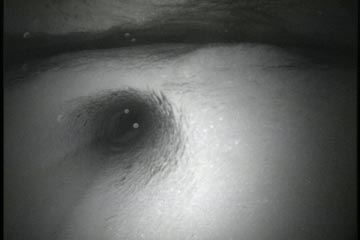
 Note the fracture at the right of the field of view. Water drained from the drill hole at this depth while drilling, which was the best indication that this was an englacial drainage passage. The depth of this feature was 83 meters below the surface of the ice. The total thickness of ice at this location was 180 meters. The compass extended from the end of the camera to measure the orientation of the fracture.
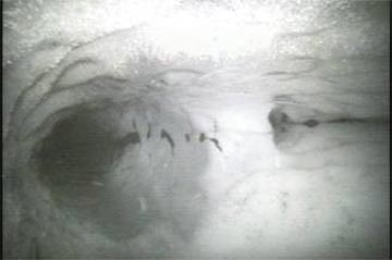
Another example of a fracture-like englacial drainage passage
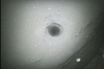
 The passage cuts from the lower portion of this photo toward the upper right. The borehole is in the top of the picture, and is about 10 cm in diameter. The depth of this drainage passage was 138 meters. Total glacier depth at this location was 150 meters. The drainage fracture shown here was hosted in clear ice, which was typical for most drainage passages that were observed.
In a few cases it was difficult to distinguish the geometry of the drainage passage
 In this case, the opening to the drainage is below the compass. Note the finger of clear ice that seems to ‘point’ into the drainage passage.
What we were expecting to find
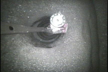
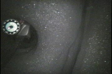
 During our third and final field season we drilled in an area of Storglaciären with a high concentration of moulins. A lot of water was descending into the glacier in the vicinity of where we drilled the hole that intersected this feature. The depth of this ‘conduit’ was 31 meters below the surface of Storglaciären. The white blurs in front of the opening to the conduit are rapidly moving particles being carried by flowing water. Water flow was measured at 15 +/-5 cm s-1
in this drainage passage. Of the 51 holes that were drilled, this is the only one that intersected a drainage passage of this type. It is significant because previous theory1 had predicted that all englacial drainage would occur in this manner. Mostly what we found was slow water flow in englacial cracks, such as that seen in the first three photographs.
During our third and final field season we drilled in an area of Storglaciären with a high concentration of moulins. A lot of water was descending into the glacier in the vicinity of where we drilled the hole that intersected this feature. The depth of this ‘conduit’ was 31 meters below the surface of Storglaciären. The white blurs in front of the opening to the conduit are rapidly moving particles being carried by flowing water. Water flow was measured at 15 +/-5 cm s-1
in this drainage passage. Of the 51 holes that were drilled, this is the only one that intersected a drainage passage of this type. It is significant because previous theory1 had predicted that all englacial drainage would occur in this manner. Mostly what we found was slow water flow in englacial cracks, such as that seen in the first three photographs.
Is Storglaciären normal? In other words, would other glaciers show englacial drainage via fractures? We believe the answer to this question is yes. Before we studied Storglaciären we spent two summers drilling into the Kennicott Glacier in Alaska. While the primary objective of the Kennicott Glacier project was quite different, we did utilize an underwater camera to view englacial drainage features. An example of one of these features is shown below.
A picture of a fracture-like drainage passage
 It was taken at a depth of 79 meters in the Kennicott Glacier, Alaska. The round feature is the borehole that had been drilled by a hot water drill. The diameter of the borehole is larger than previous pictures at 30 centimeters.
A drainage fracture taken at 123 meters below the ice surface of Kennicott Glacier
 The borehole is the round feature at center left, and the fracture crosses the lower right of the image. The fracture has a width of 10 centimeters.
The borehole should be obvious to see in this picture
 This was taken at a depth of 119 meters in Storglaciären. The width of the drainage fracture is about 10 centimeters. The brightness of the ice is indicative of hosting ice that is ‘bubbly’, which has a tendency to scatter light that lands on its surface. This was taken at a depth of 43 meters in Storglaciären. The compass was attached to the end of the camera unit to provide the orientation for the fracture. The width of this fracture is approximately 2 centimeters. The relative darkness of the photo indicates that this fracture is hosted in clear, light absorbing ice.
Water flow was detected in all cavity types, but not in all cavities that were inferred to be englacial drainage features. Only 10 of the fractures indicated flow, and were extremely slow compared with expectations from conduit models (Shreve, 1972; Rothlisberger, 1972). Flow speeds were 0.5 - 4 cm s-1, with most flow at 1 - 2 cm s-1. Tracers and water flow experiments indicated that nearby holes (10-20 m apart) could be hydraulically connected via the fractures. In one case, the connection depth in a pair of holes differed by 91 m. For the fractures that showed no flow behavior, water levels in the intersecting hole nevertheless exhibited diurnal water pressure fluctuations. Water flow was apparently imperceptibly slow in this case – the diurnal water level changes obviously indicated that water was flowing through the fracture. However, we were unable to detect this flow with the tools we employed.
Of note during the 2003 field season was the observation of two circular openings akin to the predictions of Shreve and Rothlisberger (1972). One showed no water flow and was likely an isolated cavity. The second circular opening was directly connected to a moulin. After observing many crack-like englacial fractures conveying water, we purposely searched for a circular conduit near a field of moulins into which water from surface streams was flowing. The opening was 10 cm in diameter and the water flow in it exhibited a relatively high speed of 10 cm s-1. The camera showed the conduit extending laterally into the ice on opposite sides of the hole (Figure 3).
This movie was taken with an underwater camera inside the glacier.
1Previous theory on the topic of englacial water flow had been outlined by Röthlisberger in a famous paper published in 1972. The elegant mathematics presented in this paper has been a standard bearer for glacier hydrologists for many years. For a complete copy of his paper, you are referred to the following journal article: Röthlisberger, H. 1972. ‘Water pressure in intra- and subglacial channels’. Journal of Glaciology 11, (62), 177-202.
Our paper: Fountain, A.G., Schlicting, R.B., Jacobel, R.W., and Jansson, P. 2005. Fractures as main pathways of water flow in temperate glaciers. Nature, 433, 618-621.