Outbursts from a Glacier-Dammed Lake
Andrew G. Fountain (Portland State
University)
Joseph S. Walder (US Geological
Survey)
Suzanne P. Anderson (University of
California at Santa Cruz)
Outburst floods, or
jökulhaups, occur when ice dammed water bodies drain suddenly, usually under the
glaciers. These floods are commonly much larger than storm induced floods and consequently
are more devastating in their downstream effects: they dramatically reshape stream
channels and pose a hazard to human settlements and infrastructure. Understanding timing,
size and geomorphic effect of outburst floods requires understanding mechanisms by which
impounded water is stored and released. These mechanisms remain poorly studied owing to
the unpredictable nature of outburst floods. During the summers of 1999 and 2000
we took advantage of a site with
predictable, annual outbursts to launch a systematic, multi-faceted study of outburst
floods.
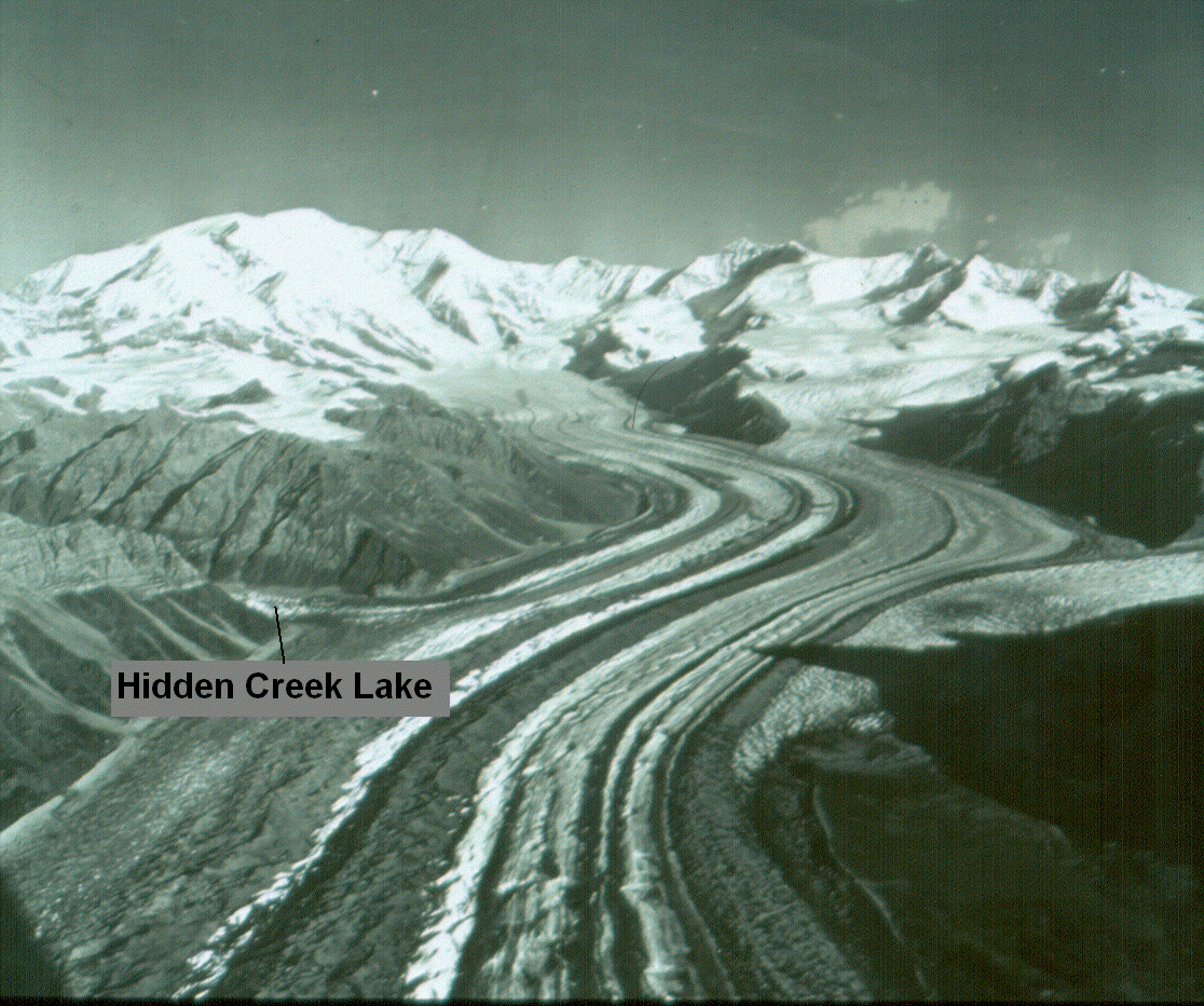 Kennicott
Glacier is located in the southwestern portion of the Wrangell Mountains of
Alaska (61o30' N, 143o W). The glacier flows from the high
peaks of the Wrangells and terminates just before the town of McCarthy.
Glacier-dammed lakes are common along the margin of the glacier, the largest of which is
Hidden Creek Lake, about 1.5 - 2 km2 (Rickman and Rosenkrans,
1997).
Kennicott
Glacier is located in the southwestern portion of the Wrangell Mountains of
Alaska (61o30' N, 143o W). The glacier flows from the high
peaks of the Wrangells and terminates just before the town of McCarthy.
Glacier-dammed lakes are common along the margin of the glacier, the largest of which is
Hidden Creek Lake, about 1.5 - 2 km2 (Rickman and Rosenkrans,
1997).
The lake drains annually, sometime
between mid-July and September since 1911 when records began. The lake drains in
about 1-2 days time, and flows under the glacier for about 12 miles where it appears at
the terminus of the glacier as the Kennicott River.
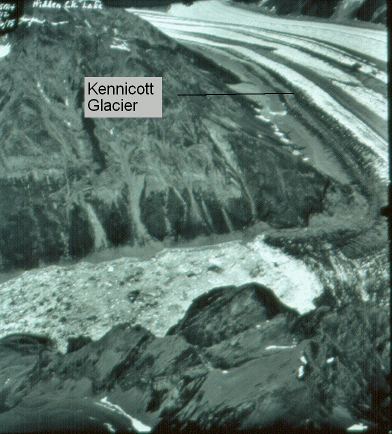
Kennicott Glacier, 27
August 1969. Photo by the U.S. Geological Survey,
Project Office-Glaciology
 The Project: The project has 3 distinct goals. The first goal is to measure the flexure of
the ice-dam in response to the lake filling (Joe Walder, USGS). This will aid in
determining the position of the hydraulic seal. The second goal is to monitor the changing
subglacial hydraulic condition as the location of the seal changes and as the lake makes a
hydraulic connection to the subglacial drainage system (Andrew Fountain, PSU). The third
goal is to measure the flood hydrograph from the glacier and assess resulting downstream
geomorphic changes (Suzanne Anderson, UCSC).
The Project: The project has 3 distinct goals. The first goal is to measure the flexure of
the ice-dam in response to the lake filling (Joe Walder, USGS). This will aid in
determining the position of the hydraulic seal. The second goal is to monitor the changing
subglacial hydraulic condition as the location of the seal changes and as the lake makes a
hydraulic connection to the subglacial drainage system (Andrew Fountain, PSU). The third
goal is to measure the flood hydrograph from the glacier and assess resulting downstream
geomorphic changes (Suzanne Anderson, UCSC).
The ice dam can be seen at right, where the glacier
ice meets the waters of Hidden Creek Lake. The odd appearance of the lake is due to
the floating ice calved off the glacier.
Photo by the U.S. Geological Survey, Project
Office Glaciology, 6 August 1975.
Team Members:
Portland State University
- Dr. Andrew G. Fountain, Principal Investigator
- Mr. Donald Lindsay, Graduate Student
- Ms. Michelle Cunico, Graduate Student
- Mr. Robert Schlichting, Vancouver School of Arts and Academics, Vancouver, WA
Robert's diary
of the 1999 field season: http://tea.armadaproject.org/tea_rschlichtingfrontpage.html
Assisted
by:
- Dr. Joel Harper, University of Wyoming
- Dr. Steve Malone, University of Washington
- Mr. Andrew Malm, undergraduate student at St. Olaf College supervised by Dr. Robert
Jacobel
US Geological Survey
- Dr. Joseph S. Walder, Principal Investigator
- Mr. Dennis Trabant
University of California at
Santa Cruz
- Dr. Suzanne P. Anderson, Principal Investigator
- Dr. Robert Anderson, Field Team Leader
- Erin Kraal, Graduate Student
- Christy Swindling, Undergraduate Student
Sharon Longacre, Undergraduate Student
National Science Foundation
This
project has been funded through the National Science Foundation Office of Polar
Programs; grant numbers
OPP9812945 and OPP9912129.
Scientific Results
1994 Lake Drainage: In late July
of 1994 Joe Walder and Carolyn Driedger made preliminary measurements of Hidden Creek
Lake. They left a time lapse camera and captured the drainage of the lake and
response of the ice dam.
VIDEO NOT WORKING
1999 Lake Drainage:
- Photos of the field work: VIEW
- A time-lapse video that captured the drainage of the
lake. VIEW
2000 Lake Drainage:
Questions? Problems? Contact: andrew@pdx.edu